Are drones taking over wind and solar O&M?
Business revenue for drone services can hit $1.6b.
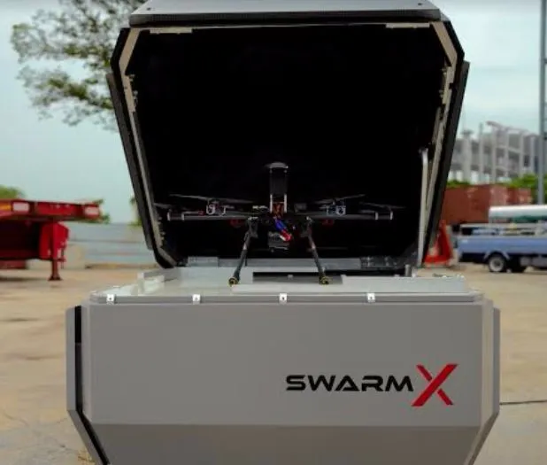
When Singaporean startup SwarmX unveiled a collaboration with DNV GL to deploy drone docking stations to monitor wind and solar farms, it was a move meant to capture the growing market of renewable energy operators in Southeast Asia that are using drones to inspect their assets.
Drone sales and services for wind turbine inspection is a booming business, with annual revenue expected to reach $1.6b by 2024, according to Navigant Research. Drone inspection is expected to increasingly complement current wind turbine blade operations and maintenance practices.
For example, SwarmX’s fully automated drone docking station, branded as The Hive, enables companies to monitor production and performance of a wind or solar asset, prevent problems form occurring, and help respond if problems arise.
“It is increasingly important for renewable energy providers to look beyond capacity to improve energy efficiency and asset optimisation,” says Mathias Steck, executive vice president Asia Pacific at DNV GL – Energy.
At the start of 2015, there were nearly 270,000 individual wind turbines operating globally, and each of these possesses a set of blades constantly exposed to the elements and suffering wear and tear. Drones are playing a larger role in helping inspect turbine blades and ensure they are in tip-top condition.
“Each individual wind turbine blade needs to be inspected at minimum once a year during a turbine’s average 20-year lifespan because blade deterioration can reduce a turbine’s ability to produce power at best and cause total system failure at worst,” says Jesse Broehl, senior research analyst with Navigant Research.
He says drones provide quicker and less risky blade inspection than rope-based techniques, and can provide highresolution images that are essential for operations and maintenance.
Can drones then be the survey and O&M instrument of the future? “It is a very useful tool, it adds many additional information to be used in initial stages (videos, aerial pictures, etc). But for high accurate digital elevation models, this technology has to be used in combination with conventional ground survey, and is seen as a useful technology helping to increase efficiency and reduce the time and costs, but not as a complete replacement of conventional surveying.
However, the simplicity, ability, and robustness of UAV are considered to be worth having,” says Talay Jiamjaratrangsee, GIS engineer at Poyry Energy in Thailand.
Operators must take into account the drop in drone performance in extreme conditions such as days that are hot and with strong winds, Jiamjaratrangsee adds.
The drone’s battery temperature increases dramatically when operating in direct sunlight, and will affect total flight time. The same goes for flying against strong winds, which drains battery life and slows down the drone.













 Advertise


